
A wind and wave map drawn for the water
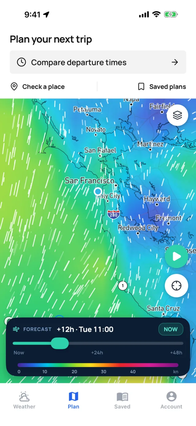
Colour fields for wind, gusts, waves, swell, rain and pressure, with the coastline drawn on top, streaks that drift with the wind and arrows for the current. Slide through the next 48 hours and watch the weather move across your route.

Read the weather the way a forecaster does
Each forecast layer paints the water by strength, on one scale you learn once. The coast is outlined over the colour, so you always know which bay you're looking at. Wind streaks drift in the direction of the wind and move faster where it blows harder.
- WindSustained wind in knots, with drifting streaks for direction.
- GustsThe peaks inside the average, where squalls and funnelling show up first.
- WavesSignificant wave height across the coast and offshore.
- SwellLong-period swell on its own, so you can see where it wraps into a bay.
- RainForecast rainfall, hour by hour.
- PressureIsobars over the colour, so you can see the lows and fronts that drive the wind.
Watch the next two days play out
Drag the slider and every forecast layer moves hour by hour through the next 48 hours. It is the quickest way to see when a front arrives, when the sea breeze fills in, and how long a blow lasts.
Pick a layer
Wind, gusts, waves, swell, rain or pressure, from the layers button.
Find your water
Pan and zoom to the stretch of coast you care about.
Slide forward
Move hour by hour and watch the weather cross the coast.
Check the numbers
Check a place on the map for its full forecast, tides and waves.
More than twenty layers, live and forecast
Forecasts show what is coming. Live layers show what is happening now. Put them together and you can see whether the forecast is running early or late.
Forecast
- Wind and gusts
- Waves and swell
- Rain
- Pressure and isobars
Live
- Rain radar
- Lightning
- Clouds
- NDBC buoys in the US
- Australian buoys
Ocean
- Sea surface temperature
- Chlorophyll
- NOAA bay and ocean model currents
- Tidal-current stations
Warnings and storms
- NWS marine warning areas
- Tropical storms from NHC
Context
- NOAA nautical charts
- OpenSeaMap seamarks
- Depth shading and contours
- Harbours from the World Port Index
Public marine data, kept fresh
| Layer | Source | Coverage |
|---|---|---|
| Wind, waves, rain, pressure | ECMWF, ICON and GFS global models | Worldwide |
| Radar, lightning, clouds | NOAA nowCOAST | US waters |
| Bay and ocean model currents | NOAA operational forecast systems and Global RTOFS, through nowCOAST | US bays and the open ocean |
| Tropical storms | National Hurricane Center | Atlantic and eastern Pacific |
| Sea temperature and chlorophyll | NASA satellite imagery | Worldwide |
| Buoys and stationsEvery 15 to 30 minutes | NDBC and the Australian Ocean Data Network | US and Australia |
| Warning areasChecked every 3 minutes | National Weather Service | US coastal and offshore waters |
| Charts and depth | NOAA charts, OpenSeaMap seamarks, GEBCO depth contours | US charts, worldwide seamarks and depth |
Conditions map questions
What does the conditions map show?
Forecast colour fields for wind, gusts, waves, swell, rain and pressure with isobars, plus live rain radar, lightning, clouds, buoys, sea temperature, chlorophyll, model currents, tidal-current stations, NWS warning areas, tropical storms, harbours and chart layers.
How far ahead does the map forecast go?
The forecast slider runs through the next 48 hours, hour by hour. For a full week, open the 7-day hourly marine forecast for any point.
What do the white streaks mean?
They drift in the direction the wind is blowing, and they move faster where it blows harder. The colour under them gives the speed in knots.
Does the map show currents?
Yes. Arrows show the current's set and strength, NOAA bay and ocean model currents follow the forecast slider, and tidal-current stations give flood, ebb and slack times.
Does the map work outside the US?
Yes. The forecast fields, sea temperature, chlorophyll, harbours and depth cover the world's coasts. Radar, lightning, NOAA charts and NWS warning areas cover US waters, and buoys cover the US and Australia.
Can I use the map offline?
Download map regions before you go and the basemap stays on screen with no signal. Your latest forecasts, tides and route weather stay on the phone for 24 hours.
Guides on reading the weather
How to read a marine forecast
Wind, gusts, seas, period, visibility and pressure trend, and what each one means on the water.
WavesSwell vs wind waves
Two kinds of sea, how they add up, and why the same height can feel completely different.
Passage planningHow to find a weather window for a coastal passage
Turn a forecast into a window that covers the whole trip, including a slow arrival.

See the weather move before it reaches you
Wind, waves, rain and pressure for the next 48 hours, on one map.